Total ALS coverage
0 M km2
23.2% of Canada's land area
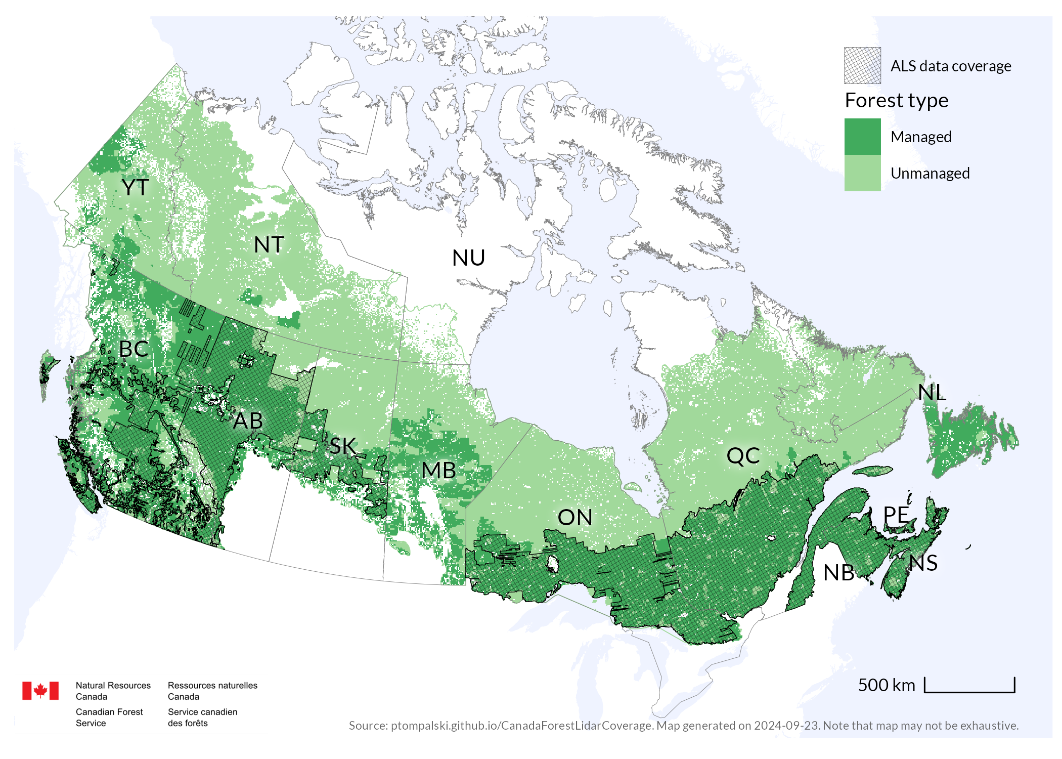
National ALS coverage overview
Current airborne laser scanning coverage across Canada's forested landscapes.
Last coverage update: May 11, 2026
Total ALS coverage
0 M km2
23.2% of Canada's land area
Forested ecozones covered
0 %
of forested ecozone area nationally
Managed forests covered
0 %
1,404,303 km2 in total
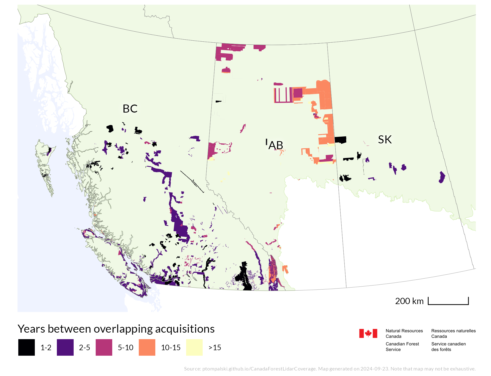
Multitemporal ALS area
0 M km2
11.3% of Canada and 24.8% of managed forests
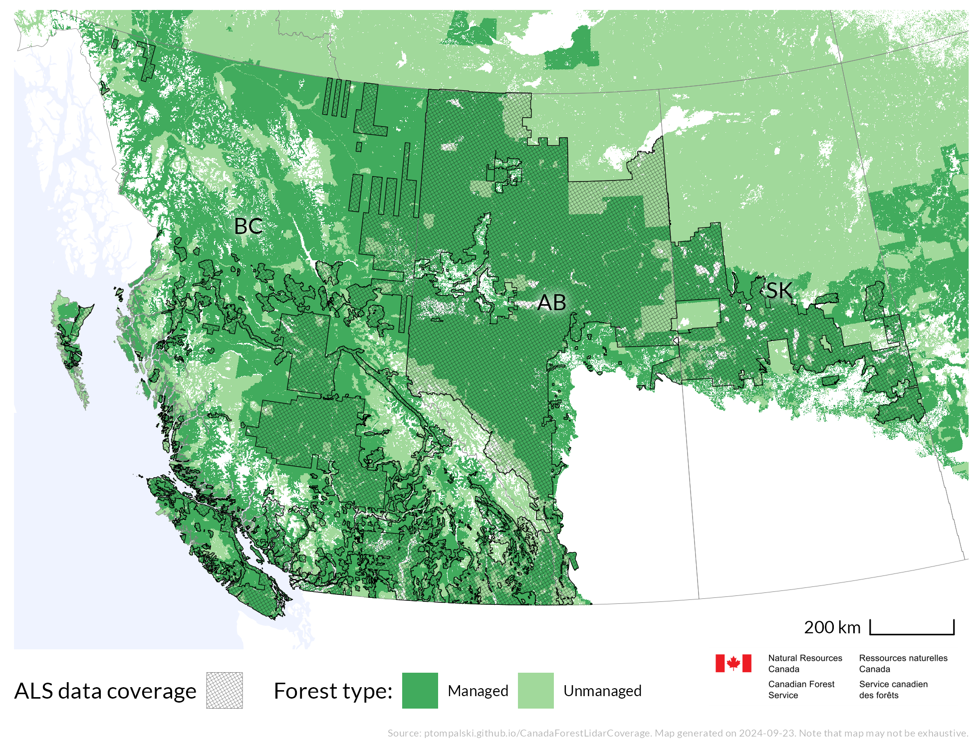
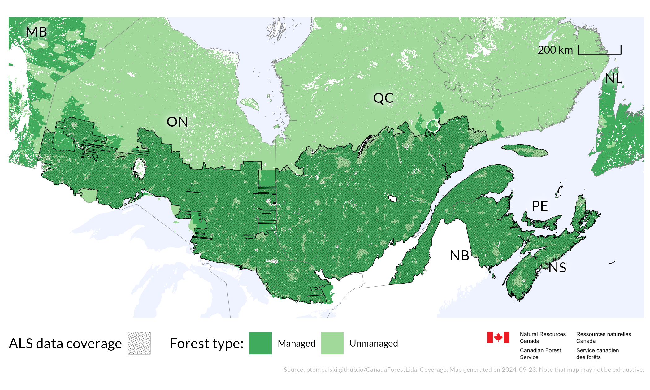
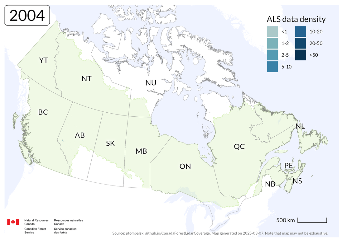
Coverage as of May 11, 2026. Dark outline indicates Canada's forested ecozones. ALS acquisitions shown on this site are limited to those ecozones. Note that the map may not be exhaustive.
The maps and descriptive statistics on this site show the current extent, availability, and characteristics of ALS data in Canada, with a focus on forestry applications. The compilation is limited to acquisitions within Canada's forested ecozones and does not include ALS collected for urban areas or individual research projects.
Coverage is compiled primarily from jurisdictional ALS data sources and, where needed, supplemented with nationally available LiDAR project coverage from Geo.ca (CanElevation Series).
| Jurisdiction | Total ALS coverage (km2, %) | ALS coverage over managed forest (km2, %) |
|---|---|---|
| British Columbia (BC) | 394,515 (42.6%) | 270,083 (54.1%) |
| Alberta (AB) | 396,537 (61.7%) | 238,443 (95.3%) |
| Saskatchewan (SK) | 145,063 (24.5%) | 71,750 (83.6%) |
| Manitoba (MB) | 22,279 (4%) | 5,001 (4.3%) |
| Ontario (ON) | 446,271 (48.6%) | 334,409 (99.8%) |
| Quebec (QC) | 550,831 (40.4%) | 375,457 (98.7%) |
| New Brunswick (NB) | 74,395 (100%) | 57,981 (100%) |
| Prince Edward Island (PE) | 5,734 (100%) | 2,429 (100%) |
| Nova Scotia (NS) | 56,587 (100%) | 37,247 (100%) |
| Newfoundland and Labrador (NL) | 19,310 (5.2%) | 11,355 (18.5%) |
| Yukon Territory (YT) | 991 (0.2%) | 71 (0.2%) |
| Northwest Territories (NT) | 811 (0.1%) | 78 (0.9%) |
Related publication
This website extends the published national overview with updated coverage sources, current summary statistics, and interactive map.
White, J.C., Tompalski, P., Bater, C.W., Wulder, M.A., Fortin, M., Hennigar, C., Robere-McGugan, G., Sinclair, I., White, R. (2025). Enhanced forest inventories in Canada: implementation, status, and research needs. Canadian Journal of Forest Research, 55: 1-37.
Suggested website citation: Tompalski, P., and White, J.C. (2026). ALS data coverage in Canadian forests. Natural Resources Canada, Canadian Forest Service. Updated May 11, 2026. Available at: https://ptompalski.github.io/CanadaForestLidarCoverage/ [accessed date].
Coverage sources and availability
The jurisdictional coverage layers in this compilation come from a mix of public download services and direct exchanges with provincial organizations responsible for ALS data management. A map showing the source provider and access category for each coverage area is available in the Data source and access map. Last update is the date when the jurisdictional coverage layer in this project was refreshed, not the date of the latest ALS acquisition.
| Jurisdiction | Last update | Source and sharing |
|---|---|---|
| British Columbia (BC) | 2026-04-21 | Source: BC Ministry of Forests and lidar.gov.bc.ca. Access: ALS open data. DEM and CHM from systematic provincial acquisition will be shared. www.lidar.gov.bc.ca |
| Alberta (AB) | 2026-05-11 | Source: AB Forestry and Parks, Alberta Biodiversity Monitoring Institute (ABMI). Access: Initial provincial coverage ALS data and derivatives were acquired with a licence. Sharing is limited to GoA partners for collaborative projects and forest industry. FRIP-funded industry projects are not currently open. ABMI acquisitions will be made freely available. |
| Saskatchewan (SK) | 2025-07-17 | Source: SK Ministry of Environment. Access: ALS point clouds are not currently shared as open data. Derivatives (DEM) are shared openly, though not all are lidar-derived: environment-saskatchewan.hub.arcgis.com. |
| Ontario (ON) | 2026-04-28 | Source: Ministry of Natural Resources. Access: ALS point clouds and derivatives (DEM, CHM, DSM) are open data, available at geohub.lio.gov.on.ca. |
| Quebec (QC) | 2025-10-28 | Source: Ministere des Ressources naturelles et des Forets, Donnees Quebec. Access: ALS open data: donneesquebec.ca/recherche/dataset/donnees-lidar-du-quebec. |
| New Brunswick (NB) | 2026-05-11 | Source: NB Natural Resources and Energy Development, and GeoNB. Access: ALS data are open and available for download: www.snb.ca/geonb1/e/dc/lidar.asp. Derivatives (DEM, CHM, hillshade, slope) are also available as WMS/WCS services. |
| Prince Edward Island (PE) | 2024-07-18 | Source: Prince Edward Island Department of Environment, Energy and Climate Action. Access: ALS point clouds and derivatives are open data, available through the Prince Edward Island data portal. |
| Nova Scotia (NS) | 2025-07-17 | Source: NSGI Data Locator and Department of Natural Resources and Renewables. Access: ALS files and derivatives are open data through the NSGI Data Locator. |
| Supplemental national source | 2026-04-28 | Source: Geo.ca (CanElevation Series). Access: National LiDAR project coverage metadata and downloadable point cloud products used to supplement jurisdictional sources where applicable. |
Additional ALS datasets in Canada